Thursday, 25 July 2013
ELOGeo starts Tweeting
ELOGeo Twitter account up and running so get following! https://twitter.com/elogeo
Thursday, 12 January 2012
Project Manager of the Year!
The ELOGeo team is pleased to win the JISC's "Project Management of the Year" award given to Amir, on the Geospatial Tools & Tech Events meeting, Ravensborough College, London, November 29, 2011.
More details on
More details on
Wednesday, 30 November 2011
Sharing Geospatial Data
As collected in the JISC program meeting, 29 November 2011, London.
Inputs from ELOGeo team (Amir, Suchith)
- Open data important for stimulating Innovation
- Big changes happening in data sharing with key initiatives like data.gov.uk which is very important as these are led from the top level in government and will have snowball effect over the whole landscape.
- Each university need champions for open data, to spearhead change within.
Summary of Inputs from participants:
Gregory
Addy ( EDINA)
Nicole ( Stanford University)
Steven (UCL)
Julie ( Stanford University)
Kate (Portsmouth University)
· Sharing data need to be part of JISC funding requirements.
· Tracking attribution of digital data makes easy for people to share
· Make it easy for sharing data
· Impact of research
· Deliverable as part of JISC contract (Share Geo for example)
· Provide infrastructure for institutional sharing of data
· Project sustainability
· Aggregate and anonymise data
· Crowdsourced data need to made available as open data
· Difficult to get people to share data.
· If we can have effective ways to cite data, and provide impact, to encourage sharing data.
· Creative stimulation
· Recognision for data sharing efforts
· Research councils to ensure that Publically funded research projects should ensure the data is available.
What human infrastructure do institutions need to establish for a spatial foundation?
During the JISC program meetings on 28-29 November, we have collected feedbacks towards the JISC strategic planners in two subject areas: Human infrastructure in GIS educating and GIS Data Sharing.
This is the summary of feedbacks for the first question and the next post will be about the second.
What human infrastructure do institutions need to establish for a spatial foundation?
Inputs from ELOGeo team (Amir, Suchith)
· Providing blended learning environment (e-learning + face to face) for improving spatial literacy.
· Providing tools/software with focus on open source and open standards.
· Working closely with funding agencies, data providers and universities on open data initiatives.
· Training the trainers programmes
Summary of Inputs from participants:
Patricia Carbajales (Stanford University)
Veerie van dan Eynden (UK Data Archive)
Conor Smyth (EDINA)
Steve Walsh (Aberystwyth University)
- Other disciplines awareness of GIS topics shall be started earlier in the schools/universities.
- The level of GIS courses to be task-oriented and split by level
- GIS resources may have been centred in Geography and needs to be tailored for wider range of students.
- Investment on more established trainers, as opposed to short-term helpers.
- Promoting the usefulness of GIS in other domains.
- Specialization vs generalization or Geospatial education is not thought when it is needed, those courses must be provided in a narrowed down manner when the student have real motivation/ change or curriculum.
- GIS courses to be an essential part of staff training.
- More focus on users.
- Getting help from student/postgrads to reduce costs.
- Providing advice on open geospatial software to other institutions, particularly on how to get software support.
- Professionals accreditation of the GIS teachers
- More focus on the GI science teaching not on training students specific vendor software.
- Mechanism to incorporate GIS in other disciplines module’s teaching,
- Central IS/library service for cross-disciplinary support for students.
Wednesday, 23 November 2011
ELOGeo Team @ JISC meeting London
We are pleased that the full ELOGeo Team (Mike Jackson, Amir Pourabdollah, Jeremy Morley, Suchith Anand, Kamie Kitmitto, Gail Millin-Chalabi, Didier Leibovici) will be at JISCgeo Innovation Programme Meeting on 28th-29th November in London.
We welcome all interested in E-learning for the Open Geospatial Community to come and see us to learn more about the ELOGeo platform and explore future research collaborations.
Also good to note that this is also our 50th Blog post!
ELOGeo @ 7th International gvSIG Conference, Spain
The 7th Edition of the International gvSIG Conference, organized by the gvSIG Association, will be held from November 30th to December 2nd 2011 at the Feria Valencia Convention and Exhibition Centre , Valencia , Spain. ELOGeo platform will be presented for this conference. The poster is here.
Monday, 7 November 2011
The Final Product Post (will not be the final blog post...)
ELOGeo: The e-learning resource for anyone curious about open geospatial data, tools and standards.
The primary users: Lecturers, students, researchers and the community of other specialised open geospatial organizations and international bodies including the Open Source Geospatial (OSGeo), Open Geospatial Consortium (OGC), Open Street Map, related sectors in government, NGOs, charities etc.
The project impact and usefulness: The ELOGeo project has been very successful in establishing an infrastructure and a community for sharing and disseminating knowledge of emerging open source geospatial software, data and standards. ELOGeo platform and learning materials are open to all those who are interested, and this is the key factor for the impact made by the project.
Openness is the key element in all aspects of this project. Not only is the subject is about open geospatial but also the access to the materials is open to public under open licenses, and even the framework itself is developed in open source platforms.
The ELOGeo repository was launched in June 2011 and within 5 months was successful in building a strong community of contributors and users for the project. As of November 1, 2011, ELOGeo has 58 registered users, with 66 material items (lecture notes, practicals, handouts, papers etc) submitted to the repository by the community. In this 5 month period there were over 17000 accesses of the materials from over 4000 users which demonstrate the strong demand from the targeted community.
The statistics of repository (cumulative) are presented, below:

Each repository “Item” may consists of different files (“Materials”).


This is the count of the searches performed within the repository and does not include search engine redirections

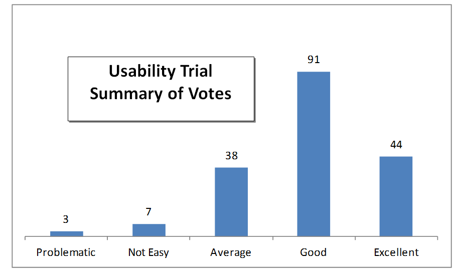
A usability survey has been conducted in the last month of the project (details at http://elogeo.nottingham.ac.uk/documents/UsabilitySurveyResults.pdf) which also helped the team to apply some improvements on the user interface. The overall look of responses shows a relative satisfaction in experiencing the ELOGeo project. The following chart shows the sum of all the collected responses.
Use Case 1: One example is the use of ELOGeo platform to disseminate the learning materials from the Open Source GIS Summer School in Girona (http://www.sigte.udg.edu/summerschool2011/) which is organized by the GIS and Remote Sensing Centre (SIGTE) of the University of Girona (Spain) with the collaboration of the Sextante Project and the Centre for Geospatial Sciences (CGS) of the University of Nottingham. The aim is to get students to learn methods, techniques and resources that will enable them to work independently in making decisions on issues about the impact on the environment and community. The ELOGeo platform has been used for the sharing of the teaching materials. The courses available cover topics from basic concepts to advanced use of Free and Open Source Software, Creating GIS Web Services, OGC specifications, Network analysis etc. Course materials are available at http://elogeo.nottingham.ac.uk/xmlui/handle/url/110
From the user’s perspective, ELOGeo can be the primary source of learning to use the open geospatial resources. From the teachers’ perspective, ELOGeo can be the primary archive for their needed material and to share them with the students. From the public perspective, this helps to get the benefits to a wider audience. Without ELOGeo, the materials could be shared online temporarily, but there was no specialized and established source for all those related materials.
Use Case 2: A non-geospatial specialist from any discipline realizes that she needs to work with the open geospatial data and software (e.g. for flood mapping). She can go through the Introduction for Beginners wiki page which covers topics such as Introducing GIS, Vector Data, Data Capture, Raster Data, Topology, Coordinate Reference Systems, Map Production, Spatial Analysis (Buffers analysis, Interpolation etc.) which are all fundamental subjects to learn to be applied in any application theme. Once they have this knowledge, they can move on to advanced topics such as web services and OGC standards which are available in the repository.
How to use ELOGeo: The users can access to the collected materials, as well as to create, upload, modify or share them with others. The user interfaces include:
o The main website (elogeo.nottingham.ac.uk) introduces the project’s aims and objectives, its team and its partners and collaborators. It also provides links to the main features of the system including the repository, wiki and blog. There is also interactive tag cloud based search facility provided to the users.

o The repository (elogeo.nottingham.ac.uk/xmlui) where the learning materials are classified and archived. The users can search and find their materials through different searching and listing tools, including full-text search. They also can register/login to the system to manage their uploads. The administrators can run the workflow of accepting/rejecting/modifying the uploaded materials as well as administrating the user accounts.

The arrangement of the ELOGeo categories and collections is inspired by the users’ requirements. The contributors can upload their materials into any branch, or suggest a new branch to the administrator. The current arrangement is as follows:
· Conference Series [5]
· FOSS4G 2008 and before [0]
· FOSS4G 2009 [0]
· FOSS4G 2010 [1]
· FOSS4G 2011 [1]
· OSGIS 2009 [0]
· OSGIS 2010 [0]
· OSGIS 2011 [3]
· Educational Series [16]
· GIS for Educators Series [10]
· GIS Summer School [6]
· OS-Geo Live DVD [0]
· Learning Materials [13]
· e-Books [2]
· Research Articles [2]
· Tutorials and Practicals [8]
· Other Types of Material [0]
· Use Cases [8]
· Disaster Management [0]
· Environmental Management [2]
· Flood Mapping [1]
· Health [0]
· Transportation [0]
For those who are new to the framework, a Users’ guide is available at elogeo.nottingham.ac.uk/documents/UsersGuide.pdf. For the new contributors, the Material Preparation Guidelines are available at elogeo.nottingham.ac.uk/documents/ELOGeoGuidelines.pdf
o The wiki (www.osmgb.org.uk/elogeowiki) where the system users can create and access the wiki-styled materials. Users will be able to take advantage of knowledge sharing in a wiki environment, including the ability to interlink, discuss and access to the previous editions if necessary. Moreover, administrators can approve/reject the changes made and manage the users’ accounts. The wiki can act as a knowledgebase on its own, as well as providing a conceptual interlinked layer over the ELOGeo repository.
The main contribution to the wiki so far is a comprehensive report made for the World Bank titled Using Spatial Data Infrastructures for Monitoring Development Outcomes: A Manual for Developing Countries, edited by Mike Jackson and Zoë Gardnera, which has been organized as a series of interlinked wiki pages. In future, we aim to link the repository and wiki in a more integrated manner.
The main contribution to the wiki so far is a comprehensive report made for the World Bank titled Using Spatial Data Infrastructures for Monitoring Development Outcomes: A Manual for Developing Countries, edited by Mike Jackson and Zoë Gardnera, which has been organized as a series of interlinked wiki pages. In future, we aim to link the repository and wiki in a more integrated manner.

o The blog (elogeo.blogspot.com) where the system developers and users can share their ideas and comments. This has been used for the initial system development posts, and can now be used for sharing news, comments etc. The blog has had 98 visitors from 16 countries so far.

Why use ELOGeo?
There is an increasing demand from both teaching staff and students for access to good quality teaching and training materials in open source geospatial technologies, standards and data and ELOGeo targets this need of the community. The ELOGeo’s aim is to cater for all levels of users (from novice to expert) who are interested in learning and using open source GIS. Also we welcome users from different disciplines (archaeology, engineering, geography, etc) who are interested to learn and use open source GIS and so have included introductory material and items on basic concepts in the ELOGeo repository.
The expanding range of Open source GIS tools greatly enhances the use of geospatial technologies by the wider community and facilitates the sharing of information and collaborative work. But in order to fully utilize the potential of these new and innovative technologies there are key challenges that need to be overcome. These include (1) a solid understanding of the technology by the wider geospatial community and (2) knowledge of how to integrate these technologies with existing theory, techniques and models. There is growing demand from the geospatial industry and academia for students with these skills. The ELOGeo vision is to provide a framework environment for the seamless sharing of geospatial and map based information and knowledge in this theme.
ELOGeo Sustainability and Future
As ELOGeo was implemented as a community led project (with strong support from Open Source Geospatial Foundation, Open Geospatial Consortium etc) and over the 5 months since launch had attached many contributors and users for the system. We envisage that more people will continue materials contributions and user base increase over time. In the medium term, University of Nottingham will keep hosting the basic infrastructure for this but we will need to find funding to get staff time to help maintain this long term. We hope JISC and other funders will realize the strategic importance of this initiative and its impact and take necessary steps to ensure support for the ELOGeo platform.
The next step if the above continuation support is given will be a more generalized research on the sustainability of a crowd-sourced learning framework, having ELOGeo as the case study. We believe that focusing on issues such as Semantic Linking and Body-of-Knowledge development can be the key future research topics.
Meet the ELOGeo Team
 Prof. Mike Jackson |  Amir Pourabdollah |  Suchith Anand |  Jeremy Morley |
 Didier G. Leibovici |  Kamie Kitmitto |  Yin Min Tun |  Gail Millin-Chalabi |
More Details of team including their background and contact information is available from http://elogeo.nottingham.ac.uk/os_team.html
Table of Contents for Project Blog:
February | |
March | |
April | |
May | |
June | |
July | |
August | |
September | |
October | |
Other project documentations are also available at http://elogeo.nottingham.ac.uk/os_documents.html
Subscribe to:
Posts (Atom)